Assessment and Spatial Mapping of Soil Degradation Status in Bontoharu District, Selayar Islands Regency: A Framework for Sustainable Land Management


Abstract
This research conducts a comprehensive spatial assessment of the soil degradation status in the Bontoharu District, Selayar Islands Regency, to facilitate evidence-based sustainable land management strategies. By employing an integrated methodological framework that combines GIS-based spatial analysis, field surveys, and laboratory testing, the study evaluates various parameters, including physical, chemical, and biological properties of the soil. Key environmental factors examined include rainfall patterns, topography, soil typology, and land use practices. Primary data obtained from field sampling was supplemented with secondary data sources, including CHIRPS rainfall data (2014-2023), digital elevation models, and official land use classifications. The findings indicate that while 81.78% of the study area demonstrates low degradation levels, approximately 18.22% encounters significant soil degradation challenges, with 7.85% classified as very critical. The spatial distribution analysis revealed that surface rock fragments, shallow solum depth, and unfavourable soil physical properties are the predominant limiting factors. The areas most vulnerable to degradation correlate with steep slopes (greater than 45%) and intensive agricultural activities. The study outlines spatially explicit recommendations for targeted conservation interventions, including reforestation in critical areas (1,288.42 hectares), community forest development (1,018.54 hectares), organic matter amendments, and enhancement of land use practices. This research highlights the importance of integrated spatial assessments in formulating location-specific conservation strategies and provides a methodological framework that is applicable to similar island ecosystems facing soil degradation challenges.
1. Introduction
Land plays a vital role in sustaining ecosystem sustainability and supporting human activities, particularly in agriculture and regional development. According to the Food and Agriculture Organization (FAO), land is defined as a physical environment that encompasses various components, including climate, topography, soil, and other factors influencing the potential use of the land (Šarapatka & Bednář, 2022). However, in recent decades, land degradation has emerged as an increasingly alarming global threat, particularly due to the heightened exploitation of natural resources without regard for conservation considerations (Adnan, 2020).
Land degradation frequently results from unsustainable management practices, leading to severely compromised land conditions. Adnan (2020) indicates that severely degraded land refers to land that has lost its productive capacity as a consequence of management practices that neglect soil and water conservation, ultimately resulting in erosion and physical deterioration. As noted by Šarapatka and Bednář, soil erosion is the predominant form of land degradation and significantly contributes to the decline of soil quality and productivity (Šarapatka & Bednář, 2022). This situation is further aggravated by the increasing frequency of extreme climatic events, which are anticipated to exacerbate erosion in agricultural zones characterized by farmland (Bian et al., 2023).
Soil degradation, which contributes to the emergence of severely compromised land conditions, is instigated not solely by poor management but also by phenomena such as nutrient depletion and erosion. According to Trigunasih and Wiguna, the loss of organic matter and the accumulation of detrimental compounds can diminish soil productivity and disrupt ecosystem functions (Trigunasih & Wiguna, 2020). Degradation stemming from soil erosion directly eliminates the fertile soil layer, which plays a crucial role in supporting plant growth and retaining water. Research by Zubair further substantiates the assertion that land situated in areas with steep slopes is highly susceptible to degradation due to erosion, underscoring the importance of maintenance practices in these regions (Wen et al., 2024).
In this context, the categorization of severely degraded land necessitates a comprehensive understanding of several parameters, including land cover and land management practices. The Ministry of Forestry elucidates the classification of severely degraded land into distinct categories: non-critical, somewhat critical, potentially critical, critical, and very critical, which aids in determining priorities for land rehabilitation (Abiye, 2022). Nevertheless, regions such as the Selayar Islands continue to encounter significant challenges in the management and monitoring of soil conditions, which presents an obstacle to efforts aimed at soil recovery (Du et al., 2021).
Given the existing challenges, integrated mitigation measures are imperative, encompassing the adoption of improved soil conservation techniques and sustainable resource management practices. Recent research indicates, as highlighted by Koirala et al. 2019 that the implementation of the RUSLE model in soil management can facilitate the estimation and mitigation of soil erosion rates (Koirala et al., 2019). By employing data-driven modelling and effective survey systems, initiatives to rehabilitate severely degraded land and conserve soil can be conducted more systematically and with greater foresight (Chi et al., 2022; Mandal et al., 2023). Thus, for the effective supervision and control of soil degradation, it is essential to first undertake inventory activities pertaining to soil condition data and its degradation, which should subsequently be represented as a soil degradation status map for Bontoharu District in Selayar Islands Regency.
Several primary parameters that influence the classification of severely degraded land encompass land cover, slope gradient, erosion level, land productivity, and land management, as stipulated in Forestry Regulation Number P. 32/Menhut- II/2009. The stratification of severely degraded land levels is categorized into five classifications: non-critical, somewhat critical, potentially critical, critical, and very critical. Selayar Islands Regency faces challenges regarding insufficient data on soil conditions and degradation status, both in terms of geographical extent and distribution patterns. Consequently, to ensure effective supervision and control of soil degradation, initial actions are required in the form of conducting an inventory of soil condition data and assessing the degradation status.
The Selayar Islands Regency is among the regions grappling with significantly degraded land conditions, which can be attributed to both natural and anthropogenic factors. Unsustainable land use practices, extensive land conversion, and high rainfall intensity are the primary contributors to the accelerated soil degradation within this area. In recent years, the situation has become increasingly alarming due to the expanding areas of land experiencing severe erosion and a marked loss of soil fertility (Boyaj et al., 2020; Wulandari et al., 2022). Furthermore, the Selayar Islands are suffering from serious land degradation issues induced by both natural and anthropogenic factors, such as unsustainable land use patterns, extensive land conversion, and high rainfall intensity. These factors contribute to severe erosion and the degradation of soil fertility in the region, thereby raising significant concerns regarding food security and the welfare of local communities. To mitigate this issue, there is a pressing need for scientific studies that accurately ascertain the status of soil degradation and its contributing factors. Research focused on developing soil degradation status maps through spatial modeling in Bontoharu District will employ spatial analysis methods that have demonstrated accuracy, thus providing valuable references for more sustainable land management practices (Ahmad et al., 2022; Kalogiannidis et al., 2022).
This research presents an innovative methodology for the mapping and analysis of soil degradation status through the application of spatial modeling techniques utilizing satellite data and Digital Elevation Models (DEM). These methods offer improved accuracy compared to traditional techniques reliant on manual surveys. The employed methodologies encompass GIS-assisted spatial analysis and machine learning to ascertain the primary factors contributing to land degradation within specific regions. This approach is consistent with the findings of Hälbac-Cotoară-Zamfir et al. (2022), which emphasize the importance of landscape ecology perspectives in identifying the risks associated with soil degradation (Hälbac-Cotoară-Zamfir et al., 2022). Unlike previous studies that predominantly concentrated on the physical attributes of soil, this research integrates the interactions among land cover patterns, rainfall, and anthropogenic activities in its assessment of the severity of land degradation. This is consistent with findings by Schillaci et al. (2022), which illustrate the importance of local and landscape factors in understanding the impacts on soil degradation (Schillaci et al., 2022). Furthermore, socio- economic aspects are examined using population density data and land use patterns. The multidisciplinary approach proposed by Pan et al. (2023) is also pertinent in this context, even though its focus is on land degradation across different regions (Pan et al., 2023). The model discussed by Mandal et al. (2020) aids in understanding the effects of erosion but does not specifically address the integration of socio- economic components (Mandal et al., 2020).
The objective of this research is to map the soil degradation status in Bontoharu District, Selayar Islands Regency, serving as a reference for managing and monitoring soil degradation to support biomass production while maintaining the environmental and economic functions of the soil. With these mapping results, mitigation strategies can be developed more effectively to avert land degradation and ensure sustainable soil use utilization.
2. Method
1) Research Location and Time
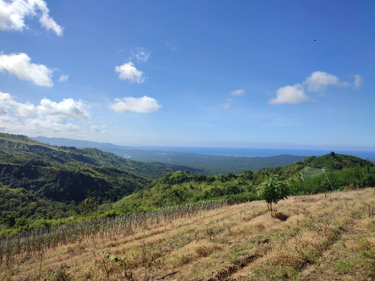
This research was conducted in the Bontoharu District, Selayar Islands Regency, over a three-month period from June to September 2024. The observation location covered the administrative area of Bontoharu District, Selayar Islands Regency.
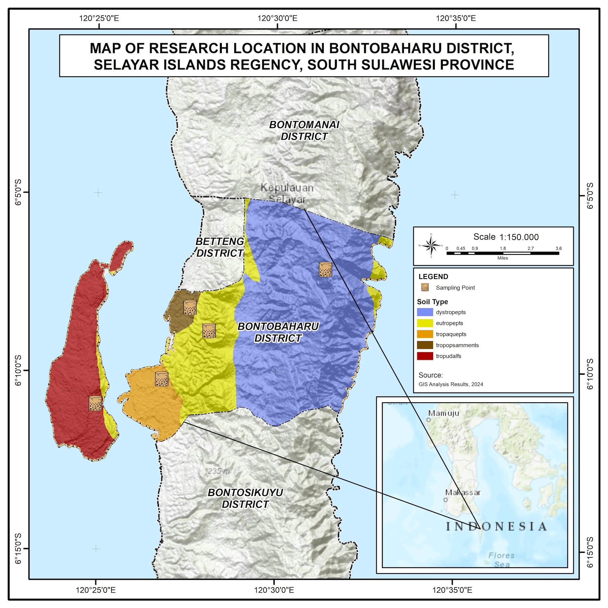
Figure 1. Research Location Map
2) Tools and Material
This research used a quantitative approach with spatial analysis to evaluate key parameters of basic soil properties, covering physical, chemical, and biological aspects, in order to understand the status of soil degradation for biomass production. With this analysis, mitigation measures can be designed more effectively to improve agricultural productivity and environmental sustainability. The main equipment used included a Garmin GPS MAP 78S to accurately determine soil sample points, as well as Geographic Information System (GIS) software to process spatial data and systematically map the distribution of soil properties and land degradation levels. Laboratory analysis of soil properties was carried out using a pH meter to measure soil acidity, a drying oven to determine water content, and an analytical scale to measure sample weight with high precision.
Soil sampling was conducted using a systematic method based on a predetermined soil type distribution map from a 1:50,000 scale soil type map. Each sampling point was systematically selected considering the topographic variation and land use in Bontoharu District to ensure data representativeness. Soil samples were collected using a soil borer, then stored in sterile containers to prevent contamination during the analysis process. Soil physical parameters, including texture, water content, and porosity, were analyzed in the laboratory using the pipette method to determine particle fractions and the gravimetric method to measure soil water content with high accuracy.
In the chemical analysis, soil pH content was measured using a pH meter, while nutrient content such as nitrogen, phosphorus, and potassium was analyzed using a spectrophotometer and the Kjeldahl method. Chemicals used in the testing included HCl solution, H2SO4, and buffer solutions that comply with soil laboratory standards. Additionally, analysis of cation exchange capacity (CEC) and base saturation was carried out to understand the soil's ability to provide nutrients for plants. For biological analysis, soil microbial activity was measured using the method of counting the number of living microorganisms in soil samples. Specific growth media were used to identify microorganisms that play a role in soil fertility. Additionally, the respirometry method was applied to measure the rate of microbial respiration as an indicator of soil biological health. Spatial data obtained from GIS was combined with laboratory results to perform spatial modeling analysis. The spatial data used included soil type maps, topography maps, slope maps, land use maps, geology maps, and rainfall maps. Using GIS software, soil degradation status maps were created based on the physical, chemical, and biological parameters that had been analyzed. This model was used to identify areas with high levels of soil degradation and design more effective land conservation strategies
Primary data was obtained through field survey activities related to the physical conditions in the study area. Secondary data used included rainfall data for the last 10 years (2014-2023) obtained from Climate Hazards Group Infrared Precipitation with Stations (CHIRPS), soil type data from the RePPProT Geospatial Information Agency 2022, land use data from the Ministry of Environment and Forestry (KLHK) 2022 (Ministry of Environment and Forestry of the Republic of Indonesia, 2022), as well as slope data analyzed from the Digital Elevation Model (DEM).
3) Research Implementation
The procedures for measuring soil degradation for biomass production are regulated in the Ministry of Environment Regulation No. 07 of 2006. In Government Regulation No. 150 of 2000, soil degradation is defined as a change in the basic properties of soil that exceeds the standard criteria for soil degradation under specific conditions of place and time, assessed based on standard soil degradation criteria. The standard criteria for soil degradation refer to the Republic of Indonesia Government Regulation No. 150 of 2000. Meanwhile, the study methodology fully refers to the Guidelines for Assessment of Soil degradation for Biomass Production from the Ministry of Environment in 2009. This research was conducted through several stages. First, primary data collection was carried out through field surveys to observe the physical condition of the soil in the study area. Second, secondary data collection included rainfall data for the last 10 years (2014-2023) obtained from Climate Hazards Group Infrared Precipitation with Stations (CHIRPS), soil type data from RePPProT Geospatial Information Agency 2022, and land use data from the Ministry of Environment and Forestry. The rainfall data used was monthly data analyzed using descriptive statistical methods to identify rainfall patterns and their correlation with soil degradation levels. The next stage was data analysis. Field and secondary data were processed using spatial overlay techniques using GIS software to determine the distribution of soil degradation. Additionally, statistical analysis was conducted to link environmental factors with soil degradation levels. The results of this research are expected to provide data-based recommendations for more sustainable land management.
4) Data Analysis
The soil degradation status map for biomass production is the final output containing information about the status, distribution, and extent of soil degradation in the mapped area. This map is compiled through two main evaluation stages, namely the matching method and Risk Factor (RF) scoring. In detail, the determination of soil degradation status is described as follows:
Filtering of effective work areas, the initial stage of preparing the soil condition map. The soil condition map is descriptive, meaning this map only provides an overview of soil properties in the surveyed area. The soil condition map is compiled based on the results of identification and inventory of soil properties in the field and subsequently the map is refined with data from laboratory analysis results. The soil condition map contains parameter values for standard soil degradation criteria. Values are included in the map legend in the form of range values for each parameter. This map also contains information on land conditions obtained from thematic maps, namely soil type, parent material, slope, annual rainfall, and land use. In the next stage, data from this map will be assessed and form the basis for the preparation of the soil degradation status map for biomass production.
Scoring of soil degradation potential, the scoring or weighting score for soil degradation potential is obtained from the multiplication of the rating value, which is the potential value of each thematic map element for soil degradation occurrence, with the weight value of each thematic map, namely the soil map, slope map, rainfall map, and land use map.
Overlay of thematic maps, after the effective work area and score values from each thematic map are obtained, an overlay of thematic maps is performed on that area. This overlay process will produce new polygons with soil condition attributes according to the constituent thematic maps. In this new polygon, the potential for soil degradation will be assessed by considering the weighting score for soil degradation potential from its constituent maps.
Determination of soil degradation, soil degradation potential is estimated by grouping the accumulated weighting scores, which are the product of the score value and the weight of each thematic map.
5) Scoring of Soil Degradation Potential
The scoring value or weighting score for soil degradation potential is obtained from the multiplication of the rating value, which is the potential value of each thematic map element for soil degradation occurrence, with the weight value of each thematic map, namely the soil map, slope map, rainfall map, and land use map. The rating value is set to range from 1 to 5. Meanwhile, the weight value is based on the accuracy of each thematic map information in the assessment of soil degradation potential. Land use maps and soil maps are given a weight value of two (2), and slope and rainfall maps are given a weight of three (3). The higher the weighting score obtained, the higher the potential for that region to experience soil degradation, as explained below.
Soil Map
Based on the Soil Taxonomy classification system, 10 soil orders are distributed in Indonesia: Histosols, which is an order for wet soils, and Entisols, Inceptisols, Vertisols, Andisols, Alfisols, Ultisols, Oxisols, and Spodosols, which are orders for dry land soils. Based on their moisture conditions, soils are divided into wet land soils and dry land soils. Wet land soils are soils that for most of the time in normal years are in water-saturated conditions. Meanwhile, dry land soils are soils that for most of the time in normal years are in unsaturated conditions. Dry land and wet land soils can be inferred from their soil type names. Besides Histosols, wet lands include mineral soils that have an aquic moisture regime or aquic suborder, for example, Aquents, Aquepts, Aquults, Aquods. In estimating degradation potential, soils are grouped into 5 (five) classes of soil degradation potential. The rating value for soil degradation potential is given primarily based on the soil erodibility value approach.
Table 1. Soil order-based erodibility classification

In relation to soil degradation, the slope gradient level greatly influences the process of soil degradation caused by soil erosion. In estimating soil degradation potential based on land slope conditions, soils are grouped into 5 (five) classes of soil degradation potential. The basis for determining slope classes is the division of slope classes used in determining severely degraded land potential as regulated in the Directorate General of Land Rehabilitation and Social Forestry, Ministry of Forestry, SK.167/V-SET/2004.
Table 2. Slope gradient classification for erosion risk assessment
Rainfall
Rainfall is one of the main agents of soil degradation through the erosion process. For this, the availability of data through rainfall maps is very necessary for assessing soil degradation potential. Rainfall grouping is based on the grouping of annual rainfall in the Atlas of Agricultural Climate Resources of Indonesia compiled by the Bogor Research Institute for Agroclimate and Hydrology. The class of annual rainfall in relation to soil degradation potential is presented in the following table.
Table 3. Rainfall-based classification for erosion risk assessment
Land Use
The assessment of soil degradation potential based on land use is approached by referring to the plant coefficient (C factor). Based on this approach, types of land use (both in agricultural areas and natural vegetation) are grouped into 5 classes of soil degradation potential as presented in the table below. Even though the information on land use units is more general, more detailed information regarding types of commodities/vegetation, management types, and conservation measures applied that are closely related to soil properties is very important and useful in estimating soil degradation potential. Therefore, this data is important to record and consider in utilizing land use maps for the preparation of initial soil condition maps.
Table 4. Land cover factor classification for soil erosion risk
6) Data Processing
After the effective work area and score values from each thematic map are obtained, an overlay of the thematic maps is performed on that area as mentioned. This overlay process will produce new polygons with land condition attributes according to the constituent thematic maps. In this new polygon, the potential for land degradation will be assessed by considering the weighting score for soil degradation potential from its constituent maps
7) Determination of Soil Degradation Potential
Soil degradation potential is estimated by grouping the accumulated weighting scores, which are the product of the score value and the weight of each thematic map. This assessment is carried out on the polygons resulting from the overlay, and refers to the Technical Guidelines for Preparation of Soil degradation Status Maps for Biomass Production from the Ministry of Environment in 2009. The scoring value or weighting for soil degradation potential is obtained from the multiplication of the rating value with the weight value of each thematic map including soil order maps, slope maps, and land use maps. The rating value is set to range from 1 to 5. Land use and soil type maps are given a weight value of 2, and slope maps are given a weight of 3. The lowest value is 10 and the highest value is 50; in principle, the higher the score value on each polygon, the higher the potential for that area to experience soil degradation. The criteria for grouping land degradation risk are presented in the following table:
Table 5. Classification of Land Degradation risk based on composite scores
Source: Ministry of Environment 2009.
The maximum value occurs if all attribute values from each thematic map used have a very high potential for soil degradation. The criteria for grouping soil degradation potential are presented in the table below. This map will be used as a working map and aims to facilitate and direct verification in the field, especially in determining the priority of locations to be surveyed and the types of measurements to be carried out. For this purpose, it is necessary to include important factors or factors suspected to be causes of soil degradation, namely soil type, parent material, slope, annual rainfall, and land use (Asdak, C. 2002).
8) Preparation of Soil degradation Status Map for Biomass Production
The weighted methodology pertaining to the relative frequency of soil degradation is conducted by evaluating the relative frequency of soil designated as degraded at a specified location. The relative frequency (%) of soil degradation represents the percentage value of soil degradation, calculated through the ratio of the number of soil samples identified as degraded- specifically, the measurement results of each soil degradation parameter that adhere to the established criteria for soil degradation- relative to the total number of observation points executed within that polygon. In assessing the status of soil degradation, the following steps are undertaken: a. Calculate the relative frequency (%) of each soil degradation parameter; b. Assign a score value for each parameter based on its corresponding relative frequency, utilising a range of values from 0 to 4; c. Aggregate the score values for each criterion of soil degradation parameters; d. Assess the soil degradation status based on the cumulative score values c.
Table 6. Threshold values for soil degradation parametersThreshold values for soil degradation parameters
Table 7. Soil degradation classification based on parameter frequency
Based on the sum of these score values, the categorization of soil degradation status is performed. Based on its degradation status, it is divided into 4 categories as presented in the following table
Table 8. Land degradation classification based on cumulative assessment scores
3. Result and Discussion
1) Identification of Soil Degradation Potential
The research results show that the soil types in Bontoharu District are dominated by the Inceptisols order, covering an area of 10,466.76 ha or 80.67%, followed by Alfisols at 2,223.71 ha (17.14%) and Entisols at 263.85 ha (2.19%). The dominance of Inceptisols indicates that soils in this region are in an immature development stage, with moderate to high fertility levels, depending on their organic matter and mineral content. The presence of Alfisols, which are typically found in areas with relatively high rainfall, shows good fertility potential for agriculture, although conservation management is required to maintain soil stability. Meanwhile, Entisols, which have a small distribution, tend to be found in areas with high erosion rates or soils that have not developed significantly.
Regarding land slope conditions related to soil degradation levels, the research classifies soil degradation levels based on slopes. The data shows that 64.50% of the total area has a slope of more than 45%, which falls into the very high category for land degradation potential. This slope factor plays an important role in soil erosion and degradation levels because areas with steep slopes tend to experience greater surface runoff, increasing the risk of soil loss due to erosion (Wang, 2019). Conversely, land with low slopes (1-8%), which only covers 2.19% of the total area, has a very light soil degradation potential.
Spatial analysis shows that the combination of soil type and land slope becomes the main factor in determining soil degradation potential. Soils with the Inceptisols order that dominate this area have physical and chemical properties that are vulnerable to degradation if not managed properly. The combination of Inceptisols with steep slopes (>45%), which covers 7,760.38 ha or 64.50% of the total area, significantly increases the potential for erosion and land degradation. Meanwhile, the presence of Alfisols on land with moderate (16-25%) to high (26-40%) slopes requires appropriate conservation strategies to maintain soil fertility. Ecologically, the distribution of soil types and land slope levels provides an indication that land management in Bontoharu District should focus on erosion mitigation and soil conservation enhancement (Pinheiro, 2022).
Rainfall plays a significant role in determining the level of soil degradation in a region, particularly through the erosion process. Based on the annual rainfall classification from the Atlas of Agricultural Climate Resources of Indonesia, Bontoharu District has a rainfall level ranging from 2000-3000 mm/year, which is categorized as moderate. Although included in the middle category, rainfall at this level still has the potential to cause significant soil erosion, especially in areas with steep topography and lack of protective vegetation. High water flow due to rain can increase soil particle detachment, accelerate soil degradation, and worsen sedimentation levels in downstream areas.
In terms of land use, the level of soil degradation is highly dependent on the type of vegetation and human activities. Based on the analyzed data, land use in Bontoharu District shows variations in soil degradation risk levels. Natural forest land with an area of 500.49 ha (3.86%) has a very low degradation potential because the dense vegetation system plays a role in binding the soil and reducing the effects of rainfall erosion. Mixed gardens with an area of 2,689.24 ha (20.73%) have a low degradation potential because there is still sufficient land cover to inhibit surface runoff (Abdillah & Budi, 2021).
Areas dominated by permanent production forests (HPT) and fields with an area of 7,196.46 ha (55.46%) have a moderate level of soil degradation. Agricultural activities and more intensive land use tend to increase erosion risk due to reduced natural land cover. This is further exacerbated in dry field land use, which has a high soil degradation potential with an area of 2,574.17 ha (19.84%). Dry field land often undergoes repeated soil processing without adequate conservation, thus accelerating the process of soil degradation and nutrient loss. The most vulnerable to degradation is open land, which only covers 14.64 ha or 0.11% of the total area, but has a very high degradation potential. Open land has no retaining vegetation, making it very vulnerable to the direct impact of rainfall, causing topsoil leaching and significantly increasing erosion rates (Naharuddin et al., 2020).
2) Classification of Potential and Actual Land Degradation
The division of land degradation potential classes is based on the Republic of Indonesia Government Regulation Number 150 of 2000 and the Ministry of Environment Regulation Number 07 of 2006, which are subsequently scored and weighted for overlay to determine the soil degradation potential class. Based on the overlay results, 69.85% of the Bontoharu District area has a very low soil degradation potential, 0.35% of the area is in the moderate category, 20.33% is in the high category, and 9.47% is in the very high category. The class division consists of very low, low, moderate, high, and very high soil degradation potential. Details of soil degradation potential in the study area can be seen in Table 9.
Table 9. Soil degradation risk in Bontoharu District, Selayar Islands Regency.
The results of the Soil degradation Potential analysis show that the study location has an area of land that has the potential to become severely degraded land, which is 29.8% of the total land. For land with somewhat critical criteria (moderate degradation potential, scoring 25-34) symbol PR. III covering an area of 45.50 ha or 0.35%, high land degradation potential (weighting score 35-44) code PR IV covering an area of 2,637.31 ha or 20.33%, and very high land degradation potential (weighting score 45-50) code PR V or covering an area of 1,228.60 ha or 79.47%.
The land degradation status map presents information about the soil degradation status. In its presentation, information is packaged in a map legend containing information on soil degradation status, main parameters classified as degradationd, and soil area. The distribution of land degradation potential and severely degraded land in each village/kelurahan in Bontoharu District, Selayar Islands Regency is presented in Figure 2 and Figure 3 below:
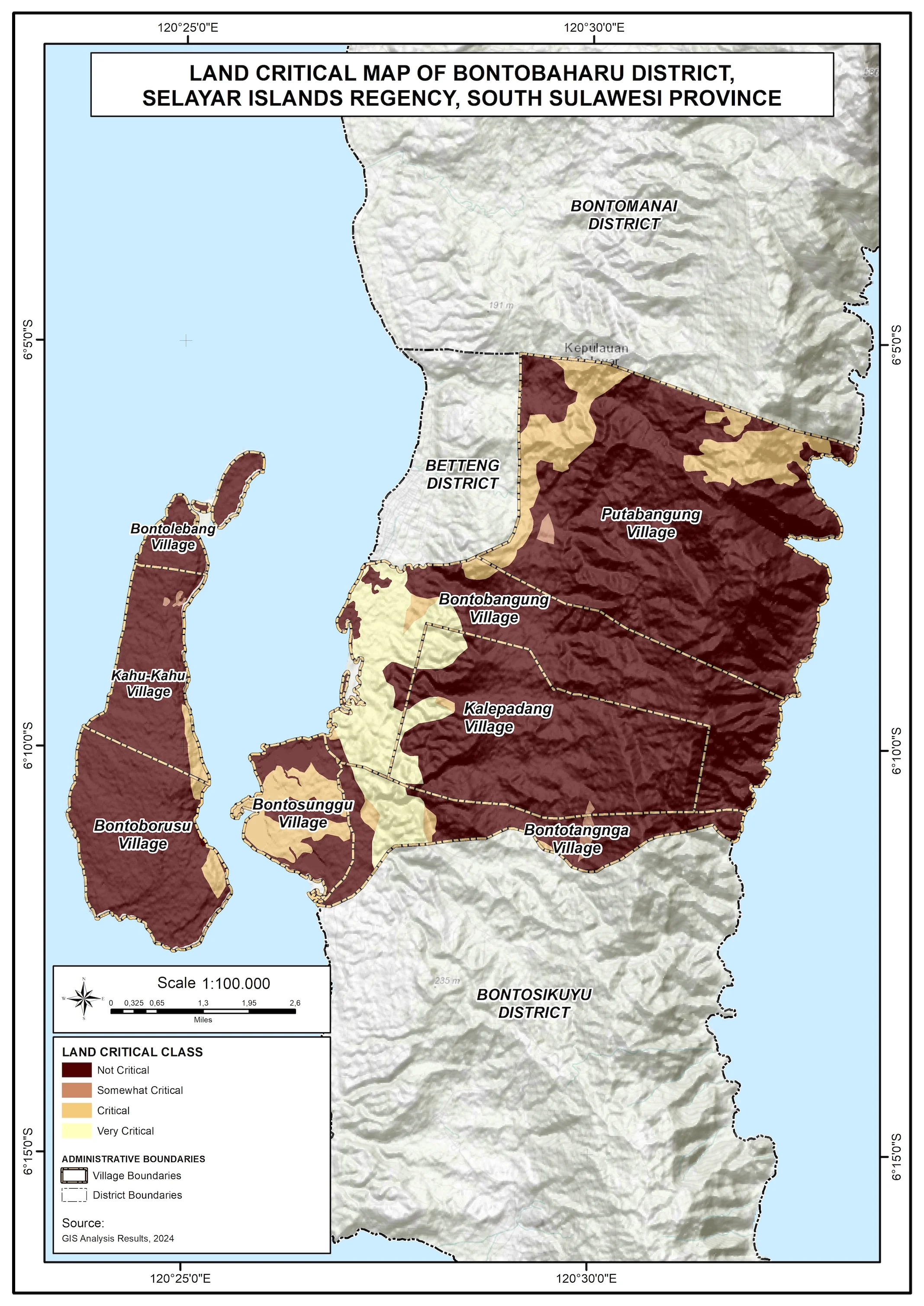
Figure 2. Soil Degradation Potential Map of Bontobaharu District, Selayar Island Regency
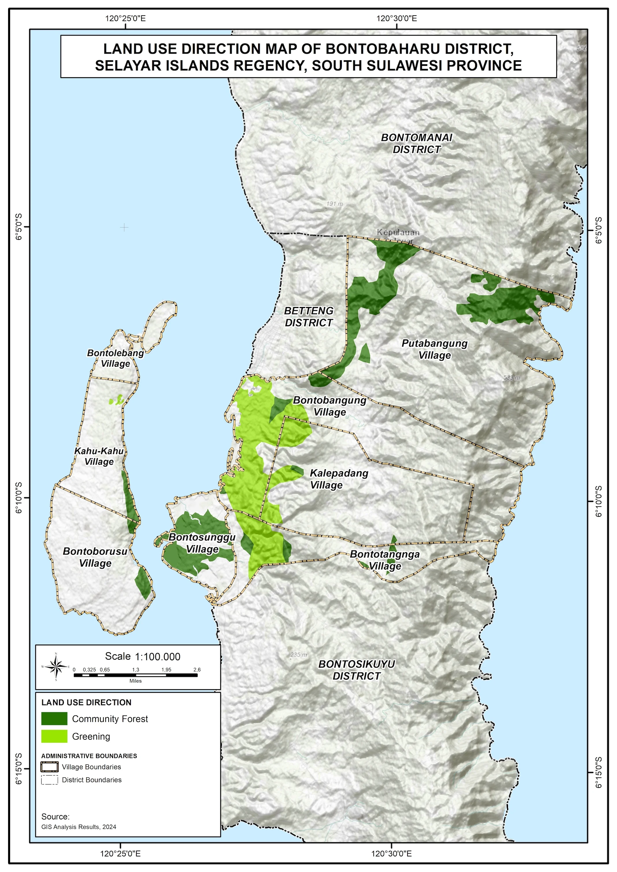
Figure 3. Soil degradation Management Direction Map of Bontoharu District, Selayar Islands Regency.
The research results show that Bontoharu District experiences various levels of soil degradation that can be categorized into four levels: slightly degradationd, moderately degradationd, highly degradationd, and very highly degradationd. Of the total analyzed area, 81.78% experiences slight degradation, while 0.44% is classified as moderate degradation. Meanwhile, 9.93% of the area experiences high soil degradation, and 7.85% falls into the very high category. The proportion of land area experiencing severe degradation indicates the need for greater attention in land management to prevent increased rates of degradation.
One of the limiting factors contributing to soil degradation in this region is the presence of surface rocks in high quantities. About 30 out of 71 identified land units show significant levels of surface rock presence, which inhibits vegetation growth and increases the risk of soil erosion (Herviyanti et al., 2022). Additionally, other factors such as soil fraction composition affect 9 land units, permeability degree affects 8 land units, and soil solum affects 15 land units. These factors indicate that the physical characteristics of the soil have a major impact on the level of soil degradation occurring in this region (Wibisono et al., 2020).
Soil acidity (pH) and redox conditions are also important factors in soil degradation. Although only affecting two land units, these factors can cause a decrease in soil fertility in the long term. Therefore, efforts to improve soil quality through amelioration methods, such as the addition of organic matter or agricultural lime, are needed to enhance the soil's capacity to support plant growth (Nurhartanto et al., 2021).
The impact of soil degradation in Bontoharu District not only affects agricultural productivity but also threatens the stability of local ecosystems. Land experiencing high to very high degradation risks accelerating erosion rates, which in turn can cause sedimentation in surrounding waters and decrease water resource quality. To address these issues, conservation-based management strategies must be implemented comprehensively. Techniques such as the use of cover crops, agroforestry systems, and terracing on sloping land can be effective mitigation measures (Basuki et al., 2023).
Table 10. Classification of Severely degraded land in Bontoharu District, Selayar Islands Regency
The determination of land degradation status is based on the relative frequency value of a series of soil property parameters that are analyzed. The assessment results show that the parameters of soil depth, surface rocks, pH parameters, electrical conductivity, sand fraction composition, total porosity, and microbes are still in the threshold category. The spatial distribution of soil degradation status is presented in Figures 2 and 3. The moderate soil degradation status with bulk density limiters is spread throughout Bontoharu District. The category of high soil degradation status with permeability, acidity, and bulk density limiters is spread almost throughout all parts of Bontoharu District. The determination of soil degradation status in Bontoharu District, Selayar Islands Regency is carried out using the analysis of various soil property parameters related to soil stability. The parameters studied include soil depth, surface rocks, pH, electrical conductivity, sand fraction composition, total porosity, and microbes. The analysis results show that these parameters are still in the threshold category, which has implications for the soil degradation status being in a moderate condition (Nurhartanto et al., 2021).
Most areas in Bontoharu District show a high soil degradation status, which is expressed through limiting values of permeability, acidity, and soil bulk density. This is in line with research conducted by Nurhartanto et al. (2021) who found that bulk density, permeability, and soil acidity are the most influential parameters in determining the level of soil degradation (Nurhartanto et al., 2021). Meanwhile, soil permeability, which is influenced by soil texture and structure, is also closely related to the porosity level of the soil. Soils with high porosity usually have a higher water infiltration rate (Anwar & Amri, 2024). The coastal environment in the study location also provides a significant impact on soil characteristics, where soils often contain acid clays which, after oxidation, can cause the soil pH to become very acidic. High herbicide use can add to the accumulation of heavy metals, such as Fe, Al, and Zn, in the root environment, which negatively impacts soil microorganisms (Kala'lembang et al., 2022). The use of chemical fertilizers that are not well managed can cause environmental problems, decrease fertility, and degradation the physical condition of the soil (Kala'lembang et al., 2022).
The utilization of open land with vegetation on vacant land is an important aspect in sustainable environmental management efforts, especially in areas with critical and very critical categories. Decreasing land use intensity, as well as the application of organic fertilizers, can support sustainable agriculture and increase the productivity of abandoned land (Dhanisa et al., 2022). The recommended appropriate land use is planting productive plants, which have the potential to improve land conditions (Edwin et al., 2023). The implementation of urban forestry can be an effective strategy in managing unused land, thus providing broader ecosystem benefits (Dhanisa et al., 2022). Land use directions for critical and very critical categories are community forests covering an area of 1,018.54 hectares or 7.85% and reforestation covering an area of 1,288.42 hectares or 9.93%. The use of appropriate technology affects the reduction of land use intensity that can suppress land (human-burdened land). If this is done sustainably, a more naturally organized land arrangement will be created (Baja, 2012). The use of organic matter effectively improves soil quality and land productivity, is also renewable, in situ, and relatively inexpensive, and supports carbon conservation in the soil (Veerasingam et al., 2021).
The recovery of soil degradation due to increased erosion hazard is an important issue, especially in the context of sustainable agriculture. Soil erosion control can be carried out through several strategic approaches, including handling erosion impacts focused on agricultural land and increasing community involvement in planning and implementing control efforts (Sutiyono et al., 2022). This is in line with findings revealed by Sutiyono et al. (2022) which show that the interaction between soil management and plant types, such as bamboo, can positively affect soil fertility and erosion control, thus strengthening the importance of local communities in the planning process (Sutiyono et al., 2022).
Research by Anshori et al. (2021) shows that the provision of organic ameliorants can increase agricultural yields, especially in growing seasons that are prone to erosion (Anshori et al., 2021). This approach is in line with efforts suggested by Sukarman et al. (2020) in improving soil quality through good management, including the addition of organic matter and control of soil moisture. Examples of methods such as improving surface drainage management are also proposed to.
4. Conclusion
This study presents a geospatial assessment framework for the evaluation of soil degradation in the Bontoharu District, Selayar Islands Regency. Our findings indicate that while a substantial portion of the district remains non-critical (81.78%), there is an urgent necessity for targeted interventions for the 18.22% of land categorised as degraded, particularly the 7.85% classified as severely degraded.
The identified limiting factors exhibit distinct spatial patterns, with physical constraints (such as rock fragments, insufficient soil depth, and unfavourable texture) predominating over chemical limitations. These patterns demonstrate a strong correlation with topographical features and land use intensity, suggesting that integrated approaches to land management are vital. In light of these findings, we recommend the implementation of a spatially explicit conservation strategy that includes: (1) the development of community forests in severely degraded areas, (2) strategic reforestation of critical zones, (3) targeted soil amendments addressing specific limiting factors in each degradation class, and (4) the modification of agricultural practices in vulnerable regions. This assessment model illustrates the importance of integrating field observations with geospatial analysis to formulate location-specific rather than generalized interventions. Future research should encompass socioeconomic dimensions, establish monitoring protocols, and evaluate land use scenarios to further promote sustainable management of these fragile island ecosystems.
5. Author Contributions
IWS is the author who initiated the manuscript writing, created the research framework, designed the method, and carried out the data analysis as well as explained the overall research results. WW as the second author assisted in the manuscript writing, designed the research method, carried out data collection in the field, and assisted in data analysis.
6. Competing Interests
The authors declare that they have no conflict of interest related to this research, either financially or non-financially, that could affect the results or interpretation of the article.
7. Acknowledgements
The authors would like to thank the parties who have provided support during this research, including Wira Bakti University and West Sulawesi University for the facilities provided. Thanks also to the field survey team who helped collect data and colleagues who provided valuable input during the preparation of this article. Technical support from the Climate Hazards Group Precipitation with Stations (CHIRPS) is also greatly appreciated in providing rainfall data.
8. References
Abdillah, M. H., dan Budi, I. S. (2021). Pembuatan dan Hasil Aplikasi Bahan Pembenah Tanah di Lahan Basah Sub-Optimal. J. Buletin Profesi Insinyur, 4(1), 23-28. https://doi.org/10.20527/bpi.v4i1.94.
Abiye, W. (2022). Soil and Water Conservation Nexus Agricultural Productivity in Ethiopia. Advances in Agriculture, 2022, 1–10. https://doi.org/10.1155/2022/8611733
Adnan, M. (2020). Land Degradation and Its Management: A Review. International Journal of Environmental Sciences & Natural Resources, 25(1). https://doi.org/10.19080/ijesnr.2020.25.556157
Ahmad, I., Adilham, A., Karma, K., & Aman, A. (2022). Application of Science and Technology for Regional Development: Tangerine Agrotourism Selayar. Mattawang Jurnal Pengabdian Masyarakat, 3(4), 436–441. https://doi.org/10.35877/454ri.mattawang1256
Anshori, A. R., Iswadi, A., Sunarya, S., & Riyanto, D. (2021). Peranan Amelioran Pupuk Organik Terhadap Hasil Padi Pada Musim Tanam Kedua Di Lahan Kering Ngawen Gunungkidul Daerah Istimewa Yogyakarta. Agrihealth Journal of Agri-Food Nutrition and Public Health, 2(1), 1. https://doi.org/10.20961/agrihealth.v2i1.48067
Anwar, S., & Amri, M. A. (2024). Hubungan Laju Infiltrasi Terhadap Permeabilitas Tanah Dan Muka Airtanah Di Daerah Desa Tajur Kecamatan Citeureup. Journal of Geoscience Engineering & Energy, 50–60. https://doi.org/10.25105/jogee.v5i1.18939
Basuki, B., Bambang Hermiyanto, & Subhan Arif Budiman. (2023). Identifikasi Dan Estimasi Kerusakan Tanah Dengan Metode Berbasis Obia Citra Satelit Sentinel-2B Dan Pembobotan Lereng Gunung Raung. Jurnal Ilmiah Rekayasa Pertanian Dan Biosistem, 11(1), 56–72. https://doi.org/10.29303/jrpb.v11i1.443
Baja, I. S. (2012). Perencanaan tata guna lahan dalam pengembangan wilayah. Penerbit Andi.
Bian, Z., Sun, G., McNulty, S. G., Pan, S., & Tian, H. (2023). Understanding the Shift of Drivers of Soil Erosion and Sedimentation Based on Regional Process‐Based Modeling in the Mississippi River Basin During the Past Century. Water Resources Research, 59(8). https://doi.org/10.1029/2023wr035377
Boyaj, A., Dasari, H. P., Hoteit, I., & Ashok, K. (2020). Increasing Heavy Rainfall Events in South India Due to Changing Land Use and Land Cover. Quarterly Journal of the Royal Meteorological Society, 146(732), 3064–3085. https://doi.org/10.1002/qj.3826
Chi, W., Wang, Y., Lou, Y., Na, Y., & Luo, Q. (2022). Effect of Land Use/Cover Change on Soil Wind Erosion in the Yellow River Basin Since the 1990s. Sustainability, 14(19), 12930. https://doi.org/10.3390/su141912930
Dhanisa, R., Muhardi, M., Indrawati, U. S. Y. V., Sugianto, S., & Kharisma, N. (2022). Pengelolaan Lahan Gambut Berbasis Biomassa Lokal Di Desa Jangkang Dua, Kabupaten Kubu Raya Melalui Kegiatan PHP2D. Jurnal Buletin Al-Ribaath, 19(1), 146. https://doi.org/10.29406/br.v19i1.4271
Du, Z., Gao, B., Ou, C., Du, Z., Yang, J., Batsaikhan, B., Dorjgotov, B., Yun, W., & Zhu, D. (2021). A Quantitative Analysis of Factors Influencing Organic Matter Concentration in the Topsoil of Black Soil in Northeast China Based on Spatial Heterogeneous Patterns. Isprs International Journal of Geo-Information, 10(5), 348. https://doi.org/10.3390/ijgi10050348
Edwin, M., Suptrapti, H., Sulistyorini, I. S., & Aliri, A. (2023). Potensi Dan Status Kerusakan Tanah Untuk Produksi Biomassa Di Kabupaten Kutai Timur (Studi Kasus Kecamatan Long Masangat, Batu Ampar Dan Rantau Pulung). Jurnal Tanah Dan Sumberdaya Lahan, 10(1), 1–13. https://doi.org/10.21776/ub.jtsl.2023.010.1.1
Hälbac-Cotoară-Zamfir, R., Polinesi, G., Chelli, F., Salvati, L., Bianchini, L., Marucci, A., & Colantoni, A. (2022). Found in Complexity, Lost in Fragmentation: Putting Soil Degradation in a Landscape Ecology Perspective. International Journal of Environmental Research and Public Health, 19(5), 2710. https://doi.org/10.3390/ijerph19052710
Herviyanti, Maulana, A., Lita, A.L., Prasetyo, T.B., Monikasari, M., Ryswaldi, R. (2022). Characteristics of inceptisol ameliorated with rice husk biochar to glyphosate adsorption. Sains Tanah Journal of Soil Science and Agroclimatology, 19(2): 230-240. https://dx.doi.org/10.20961/stjssa.v19i2.61614
Kala’lembang, E., Wong, I. L. K., & Tanan, B. (2022). Pengaruh Penambahan Abu Serabut Kelapa Terhadap Permeabilitas Tanah Lempung. Paulus Civil Engineering Journal, 4(3), 367–374. https://doi.org/10.52722/pcej.v4i3.500
Kalogiannidis, S., Kalfas, D., Giannarakis, G., & Paschalidou, M. (2023). Integration of Water Resources Management Strategies in Land Use Planning Towards Environmental Conservation. Sustainability, 15(21), 15242. https://doi.org/10.3390/su152115242
Kementerian Lingkungan Hidup dan Kehutanan Republik Indonesia. (2022). Status Hutan dan Kehutanan Indonesia 2022.
Koirala, P., Thakuri, S., Joshi, S., & Chauhan, R. (2019). Estimation of Soil Erosion in Nepal Using a RUSLE Modeling and Geospatial Tool. Geosciences, 9(4), 147. https://doi.org/10.3390/geosciences9040147
Mandal, D., Giri, N., & Srivastava, P. (2020). The Magnitude of Erosion‐induced Carbon (C) Flux and C‐sequestration Potential of Eroded Lands in India. European Journal of Soil Science, 71(2), 151–168. https://doi.org/10.1111/ejss.12886
Mandal, D., Patra, S., Sharma, N. K., Alam, N. M., Jana, C., & Lal, R. (2023). Impacts of Soil Erosion on Soil Quality and Agricultural Sustainability in the North-Western Himalayan Region of India. Sustainability, 15(6), 5430. https://doi.org/10.3390/su15065430
Nurhartanto, N., Zulkarnain, Z., & Wicaksono, A. A. (2021). Analisis Beberapa Sifat Fisik Tanah Sebagai Indikator Kerusakan Tanah Pada Lahan Kering. Journal of Tropical Agrifood, 107–112. https://doi.org/10.35941/jatl.4.2.2022.7001.107-112
Pan, Y., Yin, Y., & Cao, W. (2023). Integrated Assessments of Land Degradation in the Three-Rivers Headwater Region of China From 2000 to 2020. Remote Sensing, 15(18), 4521. https://doi.org/10.3390/rs15184521
Permen LH No. 07 Tahun 2006. Dalam Peraturan Pemerintah No. 150 Tahun 2000
Šarapatka, B., & Bednář, M. (2022). Rainfall Erosivity Impact on Sustainable Management of Agricultural Land in Changing Climate Conditions. Land, 11(4), 467. https://doi.org/10.3390/land11040467
Sukarman, S., Dariah, A., & Suratman, S. (2020). Tanah Vulkanik Di Lahan Kering Berlereng Dan Potensinya Untuk Pertanian Di Indonesia / Volcanic Soils in Sloping Dry Land and Its Potential for Agriculture in Indonesia. Jurnal Penelitian Dan Pengembangan Pertanian, 39(1), 21. https://doi.org/10.21082/jp3.v39n1.2020.p21-34
Sutiyono, S., Dharmawan, I. W. S., & Darmawan, U. W. (2022). Kesuburan Tanah Di Bawah Tegakan Berbagai Jenis Bambu Pada Tanah Andosol-Regosol. Jurnal Ilmu Lingkungan, 20(3), 517–523. https://doi.org/10.14710/jil.20.3.517-523
Trigunasih, N. M., & Wiguna, P. P. K. (2020). Land Suitability for Rice Field and Conservation Planning in Ho Watershed, Tabanan Regency, Bali Province, Indonesia. Geographia Technica, 15(1), 124–131. https://doi.org/10.21163/gt_2020.151.11
Veerasingam, S., Ranjani, M., Venkatachalapathy, R., Bagaev, A., Mukhanov, V., Litvinyuk, D., Mugilarasan, M., Gurumoorthi, K., Guganathan, L., Aboobacker, V. M., & Vethamony, P. (2021). Contributions of Fourier transform infrared spectroscopy in microplastic pollution research: A review. Critical Reviews in Environmental Science and Technology, 51(22), 2681–2743. https://doi.org/10.1080/10643389.2020.1807450
Wen, B., Liu, C., Tian, X., Zhang, Q., Huang, S.-L., & Zhang, Y. (2024). Interactive Effects of Ecological Land Agglomeration and Habitat Quality on Soil Erosion in the Jinsha River Basin, China. Land, 13(2), 229. https://doi.org/10.3390/land13020229
Wibisono, F. M., Wibisono, F. J., Effendi, M. H., Plumeriastuti, H., Hidayatullah, A. R., Hartadi, E. B., & Sofiana, E. D. (2020). A review of salmonellosis on poultry farms: Public health importance. Systematic Reviews in Pharmacy, 11(9), 481-486. https://doi.org/10.31838/srp.2020.9.69
الحقوق الفكرية (c) 2025 Jurnal Wasian

هذا العمل مرخص بموجب Creative Commons Attribution 4.0 International License.
Copyright and License
All articles published in Wasian Journal are the property of the authors. By submitting an article to Wasian Journal, authors agree to the following terms:
-
Copyright Ownership: The author(s) retain copyright and full publishing rights without restrictions. Authors grant the journal the right to publish the work first and to distribute it as open access under a Creative Commons Attribution 4.0 International License (CC BY 4.0).
-
Licensing: Articles published in Wasian Journal are licensed under a Creative Commons Attribution 4.0 International License (CC BY 4.0). This license allows others to share, copy, and redistribute the material in any medium or format, and adapt, remix, transform, and build upon the material for any purpose, even commercially, provided that proper credit is given to the original author(s) and the source of the material

This work is licensed under a Creative Commons Attribution 4.0 International License. -
Author's Rights: Authors are permitted and encouraged to post their work online (e.g., in institutional repositories or on their website) prior to and during the submission process, as it can lead to productive exchanges and greater citation of published work.
-
Third-Party Content: If your article contains material (e.g., images, tables, or figures) for which you do not hold copyright, you must obtain permission from the copyright holder to use the material in your article. This permission must include the right for you to grant the journal the rights described above.
-
Reprints and Distribution: Authors have the right to distribute the final published version of their work (e.g., post it to an institutional repository or publish it in a book), provided that the original publication in Wasian Journal is acknowledged.
For the reader you are free to:
- Share — copy and redistribute the material in any medium or format for any purpose, even commercially.
- Adapt — remix, transform, and build upon the material for any purpose, even commercially.
- The licensor cannot revoke these freedoms as long as you follow the license terms.
Under the following terms:
- Attribution — You must give appropriate credit , provide a link to the license, and indicate if changes were made . You may do so in any reasonable manner, but not in any way that suggests the licensor endorses you or your use.
- No additional restrictions — You may not apply legal terms or technological measures that legally restrict others from doing anything the license permits.
Notices:
You do not have to comply with the license for elements of the material in the public domain or where your use is permitted by an applicable exception or limitation .
No warranties are given. The license may not give you all of the permissions necessary for your intended use. For example, other rights such as publicity, privacy, or moral rightsmay limit how you use the material.