Analysis of Characteristics and Typology of Mapili Watershed West Sulawesi Province

Main Article Content

Wahyudi Isnan
Wahyudi Isnan
Hasnawir Hasnawir

Abstract

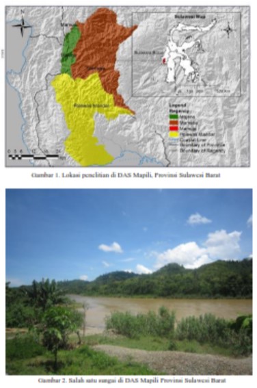
The multisectoral, multidisciplinary, multi-stakeholder and multidimensional watersheds problems are the consequences of multifunctional watersheds.  The complexity of these problems demanding a system and management approach that appropriate with the characteristics and typology of the watershed. This study aims to analyze the characteristics and typology of Mapili watershed West Sulawesi Province. This research was conducted using surveys, primary, and secondary data collection. Application of geographic information system (GIS) with overlay maps and scoring was used. The results showed that Mapili biogeophysical characterization includes meteorology, morphology, morphometry, hydrology, watershed capability and socioeconomic, cultural and institutional characterization will influence the system of Mapili watershed management. Mapili watershed can be classified into two typology watershed, namely: typology II, which has a low total population density (97 people/km2) with high rainfall (>2500 mm/yr); and typology IV, which has a high total population density (377 people/km2) with low rainfall (<1500 mm/yr). Both typologies have different characteristics of watershed problems. Typology II is generally located in the central area and upstream Mapili and Typology IV are located in the downstream areas of Mapili watershed.

Article Details

Wahyudi , W. I., Wahyudi , W. I., & Hasnawir , H. H. (2018). Analysis of Characteristics and Typology of Mapili Watershed West Sulawesi Province. Jurnal Wasian, 5(1), 21-34. https://doi.org/10.62142/jka41436
Articles

Azmeri, Hadihardaja, I. K., & Vadiya, R. (2016). Identification of flash flood hazard zones in mountainous small watershed of Aceh Besar Regency , Aceh Province , Indonesia. The Egyptian Journal of Remote Sensing and Space Sciences, 19(1), 143–160. http://doi.org/10.1016/j.ejrs.2015.11.001

Bhan, S. (2013). Land degradation and integrated watershed management in India. International Soil and Water Conservation Research, 1(1), 49–57. http://doi.org/10.1016/S2095-6339(15)30049-6

Calijuri, M. L., Castro, J. S., Costa, L. S., Assemany, P. P., & Alves, J. E. M. (2015). Impact of land use/land cover changes on water quality and hydrological behavior of an agricultural subwatershed. Environ Earth Sci, 74(6), 5373–5382. doi: 10.1007/s12665-015-4550-0

Chandniha, S. K., & Kansal, M. L. (2017). Prioritization of sub-watersheds based on morphometric analysis using geospatial technique in Piperiya watershed , India. Appl Water Sci, 7, 329–338. http://doi.org/10.1007/s13201-014-0248-9

Dubey, S. K., Sharma, D., & Mundetia, N. (2015). Morphometric analysis of the Banas river basin using the geographical information system , Rajasthan , India. Hydrology, 3(5), 47–54. http://doi.org/10.11648/j.hyd.20150305.11

Gelagay, H. S., & Minale, A. S. (2016). Soil loss estimation using GIS and Remote sensing techniques : A case of Koga watershed, Northwestern Ethiopia. International Soil and Water Conservation Research, 4(2), 126–136. http://doi.org/10.1016/j.iswcr.2016.01.002

Halengkara L, Gunawan T, & Purnama, D.S. (2012). Analisis kerusakan lahan untuk pengelolaan daerah aliran sungai melalui integrasi teknik penginderaan jauh dan sistem informasi geografis. Jurnal Majalah Geografi Indonesia, 26(2) 149–173.

Hasnawir, Kubota, T., Sanchez-Castillo, L., & Soma, A. S. (2017). The influence of land use and rainfall on shallow landslides in Tanralili sub – watershed , Indonesia. J. Fac. Agr., Kyushu Univ., 62(1), 171–176.

Hasnawir, & Sallata, M. K. (2016). Analisis daya dukung dan tipologi daerah aliran sungai Latuppa, Sulawesi Selatan. dalam Nugroho, N. P.,

Cahyono, S. A., Rahmi, I. G. A. K., Suprapto, M., Priyono, K. D., Anantanyu, S., Irawan, E. (Eds.), Seminar Nasional Peran Pengelolaan DAS untuk Mendukung Ketahanan Air (p. 290–301). Solo: Balai Penelitian dan Pengembangan Teknologi Pengelolaan Daerah Aliran Sungai.

Hasnawir, & Kubota, T. (2012). Rainfall threshold for shallow landslides in Kelara watershed, Indonesia. Int J Japan Eros Control Eng 5, 86–92. doi: 10.13101/ijece.5.86

Indarto, Wahyuningsih, S., & Affandi, I. (2010). Karakteristik hidro-meteorologi das-das di UPT PSAWS Bondoyudo-Mayang: Aplikasi statistik untuk analisis data rentang waktu. Jurnal Sains MIPA, 16(1), 35–46.

Isnan, W., & Hasnawir. (2017). Kajian daya dukung daerah aliran sungai (DAS) Mapili Provinsi Sulawesi Barat. Info Teknis Eboni, 14(2), 89–102.

Jariyah, N. A., & Pramono, I. B. (2013). Kerentanan sosial ekonomi dan biofisik di DAS Serayu. Jurnal Penelitian Sosial dan Ekonomi Kehutanan, 10(3), 141–156.

Javed, A., Khanday, M., & Rais, S. (2011). Watershed prioritization using morphometric and land use/ land cover parameters: a remote sensing approach. Journal Geological Society of India, 78, 63–75.

Kaliraj, S., Chandrasekar, N., & Magesh, S. N. (2015). Morphometric analysis of the River Thamirabarani sub-basin in Kanyakumari District , South west coast of Tamil Nadu , India , using remote sensing and GIS. Environ Earth Sci, 73, 7375–7401. http://doi.org/10.1007/s12665-014-3914-1

Kementerian Kehutanan. (2013). Peraturan Direktur Jenderal Bina Pengelolaan Daerah Aliran Sungai dan Perhutanan Sosial Nomor : P.3/V-Set/2013 Tentang Pedoman Identifikasi Karakteristik Daerah Aliran Sungai. Jakarta: Biro Hukum Kementerian Kehutanan Republik Indonesia.

Kementerian Kehutanan. (2014). Peraturan Menteri Kehutanan Nomor: P.60/Menhut-II/2014 tentang Kriteria Penetapan Klasifikasi Daerah Aliran Sungai. Jakarta: Biro Hukum Kementerian Kehutanan Republik Indonesia.

Magesh, N.S., Jitheshlal, K. V., Chandrasekar, N., Jini, K. V. (2013) Geographical information system-based morphometric analysis of Bharathapuzha river basin, Kerala, India. Appl Water Sci 3:467–477. doi: 10.1007/s13201-013-0095-0

Markose, V. J., Dinesh, A. C., & Jayappa, K. S. (2014). Quantitative analysis of morphometric parameters of Kali River basin , southern India , using bearing azimuth and drainage ( bAd ) calculator and GIS. Environ Earth Sci, 72, 2887–2903. http://doi.org/10.1007/s12665-014-3193-x

Paimin, Pramono, I. B., Purwanto, & Indrawati, D. R. (2012). Sistem Perencanaan Pengelolaan Daerah Aliran Sungai. Bogor: Pusat Penelitian dan Pengembangan Konservasi dan Rehabilitasi.

Pande, C. B., & Moharir, K. (2017). GIS based quantitative morphometric analysis and its consequences : a case study from Shanur River Basin , Maharashtra India. Appl Water Sci, 7, 861–871. http://doi.org/10.1007/s13201-015-0298-7

Patel, D.P., Srivastava, P. K., Gupta, M., & Nandhakumar, N. (2015). Decision support system integrated with geographic information system to target restoration actions in watersheds of arid environment: A case study of Hathmati watershed, Sabarkantha District, Gujarat. J Earth Syst Sci 124, 71–86. doi: 10.1007/s12040-014-0515-z

Pirani, F. J., & Mousavi, S. A. (2016). Integrating socio-economic and biophysical data to enhance watershed. Journal of Hydrology, 540(september), 727–735. http://doi.org/10.1016/j.jhydrol.2016.05.072

Presiden Republik Indonesia. (2012). Peraturan Pemerintah Nomor 37 Tahun 2012 tentang Pengelolaan Daerah Aliran Sungai. Jakarta: Kementerian Sekretariat Negara Republik Indonesia.

Rai, P. K., Mohan, K., Mishra, S., Ahmad, A., & Mishra, V. N. (2017). A GIS-based approach in drainage morphometric analysis of Kanhar River Basin , India. Appl Water Sci, 7, 217–232. http://doi.org/10.1007/s13201-014-0238-y

Republik Indonesia. (1960). Undang-Undang Nomor 56/PRP/1960 tentang Penetapan Luas Lahan Pertanian.

Sanchez-Castillo, L., Kubota, T., & Cantu-Silva, I. (2014). Root strength characteristics of understory vegetation species for erosion mitigation on forest slopes of Mexico. Int J Ecol Dev 28(2), 1–8.

Sanchez-Castillo, L., Kubota, T., Cantu-Silva, I., Moriyama, T., &

Hasnawir. (2017). A probability method of rainfall warning for sediment-related disaster in developing countries: a case study in Sierra Madre Oriental, Mexico. Natural Hazards, 85(3), 1893–1906. http://doi.org/10.1007/s11069-016-2669-2

Sanchez-Castillo, L., Kubota, T., Cantu-Silva, I., Yanez-Diaz, M., Hasnawir, & Pequeño-Ledezma, M. (2017). Comparisons of the root mechanical properties of three native Mexican tree species for soil bioengineering practices. Botanical Sciences, 95(2), 259–269. http://doi.org/10.17129/botsci.802

Singh, P., Gupta, A., & Singh, M. (2014). Hydrological inferences from watershed analysis for water resource management using remote sensing and GIS techniques. The Egyptian Journal of Remote Sensing and Space Sciences, 17(2), 111–121. http://doi.org/10.1016/j.ejrs.2014.09.003

Strager, M. P., Fletcher, J. J., Strager, J. M., Yuill, C. B., Eli, R. N., Petty, J. T., & Lamont, S. J. (2010). Watershed analysis with GIS : The watershed characterization and modeling system software application. Computers and Geosciences, 36(7), 970–976. http://doi.org/10.1016/j.cageo.2010.01.003

Sujatha, E. R., Selvakumar, R., & Rajasimman, B. (2014). Watershed prioritization of Palar sub-watershed based on the morphometric and land use analysis. J. Mt. Sci, 11(4), 906–916. http://doi.org/10.1007/s11629-012-2628-7

Supangat, A. B. (2012). Karakteristik hidrologi berdasarkan parameter morfometri DAS di kawasan Taman Nasional Meru Betiri. Jurnal Penelitian Hutan dan Konservasi Alam, 9(3), 275–283.

Thakkar, A. K., Desai, V. R., Patel, A., & Potdar, M. B. (2017). Impact assesment of watershed management programmes on land use/land cover dynamics using remote sensing and GIS. Remote Sensing Applications: Society and Environment, 5(January), 1–15. http://doi.org/10.1016/j.rsase.2016.12.001

Thomas, J., Joseph, S., & Thrivikramji, K. (2011). Morphometric analysis of the dranage system and its hydrological implications in the rain shadow regions, Kelara, India. Journal of Geographical Sciences, 21(6), 1077–1088.

Zhang, W., Zhou, J., Feng, G., Weindorf, D. C., Hu, G., & Sheng, J. (2015). Characteristics of water erosion and conservation practice in arid regions of Central Asia: Xinjiang Province, China as an example. International Soil and Water Conservation Research, 3(2), 97–111. http://doi.org/10.1016/j.iswcr.2015.06.002